


 |
市場調查報告書
商品編碼
1906873
LiDAR:市場佔有率分析、產業趨勢與統計、成長預測(2026-2031)LiDAR - Market Share Analysis, Industry Trends & Statistics, Growth Forecasts (2026 - 2031) |
||||||
※ 本網頁內容可能與最新版本有所差異。詳細情況請與我們聯繫。
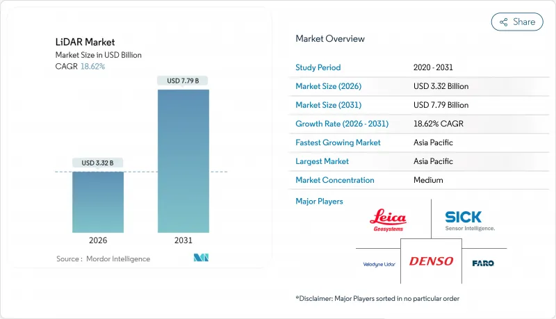
預計LiDAR市場將從 2025 年的 28 億美元成長到 2026 年的 33.2 億美元,到 2031 年達到 77.9 億美元,2026 年至 2031 年的複合年成長率為 18.62%。
成本最佳化的垂直共振腔面射型雷射(VCSEL)、成熟的單光子崩潰式二極體(SPAD) 陣列以及車規級系統晶片)正在降低量產車輛的進入門檻,同時提升偵測範圍和可靠性。聯合國 R-157 法規限制了感測器的選擇,強制要求其深度感知能力超越雷達和攝影機系統本身的能力,這為雷射雷達 (LiDAR) 市場持續符合監管要求提供了有利條件。聯邦政府的支出,例如 8.3 億美元的 PROTECT津貼和不斷擴展的美國地質調查局 (USGS) 3D高程計劃,正在支撐北美地區走廊測繪的需求。同時,中國供應商正利用其完全本土化的供應鏈和政府獎勵在全球範圍內降低價格,加劇競爭壓力,同時降低准入門檻,擴大雷射雷達市場。
全球LiDAR市場趨勢與洞察
VCSEL發射器和堆疊式SPAD探測器成本的快速下降,使得完整的車規級感測器模組價格分佈降至500美元以下,同時仍能保持300公尺的偵測距離和5公分的深度解析度。和賽計畫在2025年將產品價格進一步減半,這表明價格彈性將更多地體現在中階車型而非高階旗艦車型上,從而推動了全球超過23家OEM廠商在短期內採用該設計。歐洲汽車製造商正在同步調整產品上市週期,以充分利用不斷提升的成本績效優勢,而固態架構則無需機械致動器,從而縮短了檢驗時間。
聯合國R-157自動駕駛法規推動L3級自動駕駛LiDAR的大規模生產
聯合國R-157標準規定了高速公路自動駕駛的最低深度感知、視野和冗餘標準,這些標準無法透過攝影機-雷達組合來滿足,實際上使得雷射雷達成為所有認證的L3級自動駕駛系統的必備組件。歐盟率先實施該法規(以及中國正在製定的GB/T 45500-2025標準)將有助於實現全球平台通用,從而降低重新設計成本並加快OEM廠商的部署速度。由何賽公司主導的ISO/PWI 13228標準正在推動產業範圍內的合作,規範測試通訊協定並減少認證過程中的摩擦。
歐盟眼部安全法規禁止使用1550奈米長距離汽車LiDAR
IEC 60825-1 1 類標準對乘用車中 1550nm 雷射器的允許功率輸出有嚴格限制,導致無法實現高速公路自動駕駛所需的 200 公尺以上的實際探測距離。這促使原始設備製造商 (OEM) 將重點轉向 905nm 雷射和多感測器融合技術,但這增加了成本和架構複雜性,同時也限制了大氣滲透性更高的波長的應用潛力。
細分市場分析
到2025年,機載平台仍將維持37.45%的雷射雷達市場佔有率,因為用於洪水風險緩解、離岸風力發電選址和精密農業的位置面積測繪將持續推動飛行時間的需求。單光子測量設備現在每秒可收集1400萬個數據點,從而縮短任務時間,並提高在全國範圍內繪製走廊資產地圖的機構的投資回報率。
同時,在智慧城市和車載道路資產管理系統與高清地圖生成無縫整合的推動下,移動地面單元正以23.1%的複合年成長率快速成長。隨著自動駕駛高速公路的普及,數據採集頻率不斷提高,行動平台預計將在本十年末超越空中平台。慣性測量單元(IMU)和即時動態校正技術成本的持續下降,進一步增強了城市地區的成長動能。
到2025年,固體感測器將佔總收入的82.95%,這反映出原始設備製造商(OEM)對抗震結構和簡化組裝的重視,從而實現長期可靠性目標。固體模組雷射雷達市場預計將以18.4%的複合年成長率成長,為該細分市場中最高的成長速度,到2031年市場規模將超過61.5億美元。
頻率調製連續波 (FMCW) 技術除了測量距離外,還能測量多普勒速度,從而為感測器堆疊添加傳統飛行時間技術無法提供的瞬時運動資訊。 FMCW 不受串擾和外部光線的影響,因此能夠在車輛密集的都市區部署,即使多個車輛同時運作感測器也能正常運作。機械掃描仍將繼續用於超高解析度應用場景,但隨著晶圓級光束控制技術的成熟,其體積的不斷下降預示著不可避免的轉型。
區域分析
到2025年,亞太地區將以25.1%的複合年成長率引領成長。這主要歸功於中國汽車製造商在一次重大攝影機故障暴露出深度感知限制後,開始在中檔電動車上標準化使用LiDAR(LiDAR)。合賽科技和RoboSense利用垂直整合的供應鏈和地方政府補貼計劃,以低於全球平均水平40%的價格分佈提供感測器,推動了國內市場的廣泛應用,並為海外市場樹立了極具競爭力的標竿。國家標準GB/T 45500-2025制定了性能標準,影響了全球認證體系,促進了出口導向硬體的合規性。
北美市場依然佔據主導地位,這主要得益於聯邦政府的基礎設施支出以及創業投資投資對自動駕駛Start-Ups的大力支持。 PROTECT津貼8.3 億美元用於基於雷射雷達的氣候變遷測繪,確保了汽車行業以外的持續需求。 NASA 的 GEDI 等先進的太空計畫不斷突破技術邊界,並將衍生組件推向商業管道。加拿大大力發展海洋技術,例如 Kraken 收購 3D at Depth,正在拓展水下勘測能力並實現收入來源多元化。
在歐洲,強勁的監管勢頭與嚴格的雷射安全限制相平衡。歐盟核准2019/2144強制要求使用高級駕駛輔助系統(ADAS)並推動雷射雷達(LiDAR)的採購,但IEC 60825-1標準限制了1550nm波長在汽車應用中的使用,迫使平台開發人員在人眼安全和測距性能之間尋求平衡。北海離岸風力發電推動了對用於測深測量的雷射雷達的需求,而單光子航空感測器則縮短了跨境鐵路走廊的測繪時間。在拉丁美洲和非洲等新興市場,飛行成本的下降和蜂窩回程傳輸網路的擴展正在推動無人機搭載雷射雷達的普及,以加速可再生能源位置和礦產探勘。
其他福利:
- Excel格式的市場預測(ME)表
- 3個月的分析師支持
目錄
第1章 引言
- 研究假設和市場定義
- 調查範圍
第2章調查方法
第3章執行摘要
第4章 市場情勢
- 市場概覽
- 市場促進因素
- 突破性進展:售價低於500美元的固體感測器加速了中國和歐盟汽車設計領域的應用
- 聯合國R-157號自動駕駛法規促進L3級LiDAR的大規模生產
- 美國基礎設施法案資金籌措:走廊和氣候適應力雷射雷達測繪
- 利用無人機進行地形測繪,用於非洲和南美洲的大型可再生能源項目
- 北海和東亞近海風能測深LiDAR調查
- 對整合識別功能的暗室倉庫機器人的需求
- 市場限制
- 歐盟眼部安全法規阻礙了1550nm遠程汽車雷射雷達的普及應用
- 4D成像雷達價格壓力及其對短程ADAS感測器的影響
- 用於軌道LiDAR任務的航太級零件短缺
- 點雲資料的爆炸性成長正使各國測繪機構不堪負荷。
- 價值/供應鏈分析
- 監理與技術展望
- 波特五力分析
- 新進入者的威脅
- 買方的議價能力
- 供應商的議價能力
- 替代品的威脅
- 競爭對手之間的競爭
- 產業價值鏈分析
- 技術概述
- 測量過程選項
- 雷射選項
- 光束轉向選項
- 檢測器選項
第5章 市場規模與成長預測
- 按類型
- 航空
- 地形
- 水深測量
- 地面以上
- 移動的
- 靜止的
- 航空
- 按產品/技術
- 機器
- 固體(MEMS)
- 按組件
- 雷射掃描儀
- 導航與定位(IMU/GNSS)
- 光束控制和MEMS反射鏡
- 檢測器/接收器
- 軟體和服務
- 按範圍
- 短距離(不足100公尺)
- 中等大小(100-200公尺)
- 長(超過200公尺)
- 透過使用
- 高級駕駛輔助系統(ADAS)
- 機器人和自動駕駛汽車
- 送貨
- 走廊和地形測繪
- 環境和森林監測
- 城市規劃和智慧基礎設施
- 海洋學和水深測量
- 按最終用戶行業分類
- 車
- 航太/國防
- 土木工程/建築
- 能源與公共產業
- 農業
- 石油和天然氣
- 按地區
- 北美洲
- 美國
- 加拿大
- 墨西哥
- 南美洲
- 巴西
- 阿根廷
- 南美洲其他地區
- 歐洲
- 德國
- 法國
- 英國
- 義大利
- 西班牙
- 其他歐洲地區
- 亞太地區
- 中國
- 日本
- 韓國
- 印度
- 澳洲
- 印尼
- 亞太其他地區
- 中東和非洲
- 阿拉伯聯合大公國
- 南非
- 沙烏地阿拉伯
- 奈及利亞
- 肯亞
- 其他中東和非洲地區
- 北美洲
第6章 競爭情勢
- 市場集中度
- 策略趨勢
- 市佔率分析
- 公司簡介
- Hesai Technology
- RoboSense LiDAR
- Velodyne Lidar Inc.
- Innoviz Technologies Ltd
- Valeo SA
- Leica Geosystems AG(Hexagon AB)
- Sick AG
- Teledyne Optech
- FARO Technologies Inc.
- Topcon Corporation
- Luminar Technologies Inc.
- Ouster Inc.
- Continental AG
- Valeo Schalter und Sensoren GmbH
- DENSO Corporation
- Aeva Technologies
- Neptec Technologies Corp.(MDA)
- Argo LiDAR(Argo AI)
第7章 市場機會與未來展望
The LiDAR market is expected to grow from USD 2.8 billion in 2025 to USD 3.32 billion in 2026 and is forecast to reach USD 7.79 billion by 2031 at 18.62% CAGR over 2026-2031.
Cost-optimized vertical-cavity surface-emitting lasers (VCSELs), maturing single-photon avalanche diode (SPAD) arrays, and automotive-grade system-on-chips are lowering entry costs for mass-production vehicles while extending detection range and reliability. Regulation UN R-157 has removed optionality from sensor choice by specifying depth perception capabilities that radar-camera suites alone cannot satisfy, giving the LiDAR market a durable compliance tail-wind . Federal spending-such as the USD 830 million PROTECT grants and the expanding USGS 3D Elevation Program-anchors the corridor-mapping demand base across North America . Meanwhile, Chinese suppliers leverage complete domestic supply chains and state incentives to compress prices globally, intensifying competitive pressure but simultaneously expanding the LiDAR market by lowering adoption thresholds.
Global LiDAR Market Trends and Insights
Rapid cost compression in VCSEL emitters and stacked SPAD receivers has pushed complete automotive-grade sensor modules below USD 500 without sacrificing 300 m detection range or 5 cm depth resolution . Hesai's plan to halve list prices again in 2025 signals a price-elastic expansion toward mid-tier models rather than premium flagships, propelling near-term design-win volumes across more than 23 global OEMs . European automakers are synchronizing launch cycles to exploit the improved cost-performance curve, shortening validation timelines because solid-state architecture eliminates mechanical actuators.
Autonomous-Driving Regulation UN R-157 Triggering L3 LiDAR Ramp-ups
UN R-157 enforces minimum depth-perception, field-of-view, and redundancy benchmarks that camera-radar combinations cannot satisfy in highway automation, effectively hard-coding LiDAR into every homologated Level 3 stack. The regulation's early EU implementation, mirrored by China's forthcoming GB/T 45500-2025, enables global platform commonality, cutting OEM re-engineering costs and accelerating rollout schedules. Industry-wide collaboration through ISO/PWI 13228 chaired by Hesai is standardizing test protocols, reducing certification friction.
EU Eye-Safety Rules Hindering 1550 nm Long-Range Automotive LiDAR
IEC 60825-1 Class 1 limits severely restrict permissible laser power at 1550 nm in passenger vehicles, curbing practical detection ranges below the 200 m required for highway autonomy. OEMs therefore pivot to 905 nm or multi-sensor fusion, adding cost and architectural complexity while capping the potential of otherwise superior atmospheric-penetration wavelengths.
Other drivers and restraints analyzed in the detailed report include:
- US Infrastructure Bill Funding Corridor & Climate-Resilience LiDAR Mapping
- Drone-based Topographical Surveys for Utility-Scale Renewables in Africa & South America
- 4D Imaging Radar Price-Pressure on Short-Range ADAS Sensors
For complete list of drivers and restraints, kindly check the Table Of Contents.
Segment Analysis
Aerial platforms retained 37.45% of 2025 LiDAR market share as large-area surveys for flood-risk mitigation, offshore-wind siting, and precision agriculture drove sustained flight-hour demand. Single-photon instruments now capture 14 million points per second, cutting mission time and boosting return-on-investment for agencies mapping corridor assets at national scales.
Mobile terrestrial units, however, are expanding at 23.1% CAGR, propelled by smart-city and vehicle-mounted road-asset inventories that integrate seamlessly with HD map generation. As autonomous-ready highways proliferate, data-collection frequency rises, positioning mobile platforms to rival aerial share by the decade's end. Continued cost drops in inertial measurement units and real-time kinematic corrections reinforce growth momentum across urban regions.
Solid-state sensors accounted for 82.95% of 2025 revenues, reflecting OEM preference for vibration-proof architectures and simplified assembly that enable long-term reliability targets. The LiDAR market size for solid-state modules is on track to exceed USD 6.15 billion by 2031 at segment-leading 18.4% CAGR.
Frequency-modulated continuous-wave designs measure Doppler velocity alongside range, enriching perception stacks with instantaneous motion cues that traditional time-of-flight lacks. Immune to crosstalk and external illumination, FMCW unlocks high-density urban deployment where many vehicles operate concurrent sensors. Mechanical scanning persists in niche ultra-resolution use-cases, yet declining unit volumes suggest an inevitable transition as wafer-scale beam-steering matures.
The LiDAR Market Report is Segmented by Product/Technology (Mechanical and More), Component (Laser Scanner and More), by Range (Short (<100 M) and More), Application (Robotic Vehicle, ADAS, and Morel), Type (Aerial and Terrestrial), End-User Industry (Automotive and More), and Geography. The Market Forecasts are Provided in Terms of Value (USD).
Geography Analysis
Asia-Pacific led in growth with a 25.1% regional CAGR in 2025, driven by Chinese OEM production that now integrates LiDAR on mid-tier EVs after high-profile camera failures highlighted depth-perception gaps. Hesai and RoboSense leverage vertically integrated supply chains and provincial subsidies to offer sensors at price points that undercut global averages by up to 40%, broadening domestic adoption and setting aggressive benchmarks abroad. National standard GB/T 45500-2025 establishes performance floors that ripple across global homologation programs and incentivize export-oriented hardware conformity.
North America maintains sizable share anchored by federal infrastructure outlays and strong venture capital backing for autonomous-driving startups. The PROTECT grants allocate USD 830 million toward LiDAR-enabled climate resilience mapping, ensuring recurring demand beyond automotive verticals. Advanced space-borne programs such as NASA's GEDI continue to stretch technical frontiers and funnel spin-off components into commercial channels. Canada's offshore technology push, exemplified by Kraken's acquisition of 3D at Depth, expands underwater-survey capabilities and diversifies revenue streams.
Europe balances strong regulatory pull with stringent laser-safety limitations. Type-approval Regulation (EU) 2019/2144 compels ADAS fitment, elevating LiDAR procurement, yet IEC 60825-1 hampers 1550 nm automotive adoption, forcing platform developers to juggle eye-safety and range needs. High offshore-wind build-rates in the North Sea drive bathymetric LiDAR campaigns, while single-photon airborne sensors shorten survey windows for cross-border rail corridors. Emerging markets in Latin America and Africa increasingly deploy drone-based LiDAR to accelerate renewable-energy siting and mining exploration, benefitting from falling per-flight costs and expanding cellular backhaul coverage.
- Hesai Technology
- RoboSense LiDAR
- Velodyne Lidar Inc.
- Innoviz Technologies Ltd
- Valeo SA
- Leica Geosystems AG (Hexagon AB)
- Sick AG
- Teledyne Optech
- FARO Technologies Inc.
- Topcon Corporation
- Luminar Technologies Inc.
- Ouster Inc.
- Continental AG
- Valeo Schalter und Sensoren GmbH
- DENSO Corporation
- Aeva Technologies
- Neptec Technologies Corp. (MDA)
- Argo LiDAR (Argo AI)
Additional Benefits:
- The market estimate (ME) sheet in Excel format
- 3 months of analyst support
TABLE OF CONTENTS
1 INTRODUCTION
- 1.1 Study Assumptions and Market Definition
- 1.2 Scope of the Study
2 RESEARCH METHODOLOGY
3 EXECUTIVE SUMMARY
4 MARKET LANDSCAPE
- 4.1 Market Overview
- 4.2 Market Drivers
- 4.2.1 Breakthrough <USD 500 Solid-State Sensors Accelerating Automotive Design-wins in China and EU
- 4.2.2 Autonomous-Driving Regulation UN R-157 Triggering L3 LiDAR Ramp-ups
- 4.2.3 US Infrastructure Bill Funding Corridor and Climate-Resilience LiDAR Mapping
- 4.2.4 Drone-based Topographical Surveys for Utility-Scale Renewables in Africa and South America
- 4.2.5 Offshore Wind Bathymetric LiDAR Campaigns in North Sea and East Asia
- 4.2.6 Perception-Fusion Demand for Dark-Warehouse Robotics
- 4.3 Market Restraints
- 4.3.1 EU Eye-Safety Rules Hindering 1550 nm Long-Range Automotive LiDAR
- 4.3.2 4D Imaging Radar Price-Pressure on Short-Range ADAS Sensors
- 4.3.3 Scarcity of Space-Grade Components for Orbital LiDAR Missions
- 4.3.4 Point-Cloud Data Deluge Overloading National Mapping Agencies
- 4.4 Value / Supply-Chain Analysis
- 4.5 Regulatory and Technological Outlook
- 4.6 Porter's Five Forces Analysis
- 4.6.1 Threat of New Entrants
- 4.6.2 Bargaining Power of Buyers
- 4.6.3 Bargaining Power of Suppliers
- 4.6.4 Threat of Substitutes
- 4.6.5 Intensity of Competitive Rivalry
- 4.7 Industry Value-Chain Analysis
- 4.8 Technology Snapshot
- 4.8.1 Measurement Process Options
- 4.8.2 Laser Options
- 4.8.3 Beam-Steering Options
- 4.8.4 Photodetector Options
5 MARKET SIZE AND GROWTH FORECASTS (VALUE)
- 5.1 By Type
- 5.1.1 Aerial
- 5.1.1.1 Topographic
- 5.1.1.2 Bathymetric
- 5.1.2 Terrestrial
- 5.1.2.1 Mobile
- 5.1.2.2 Static
- 5.1.1 Aerial
- 5.2 By Product/Technology
- 5.2.1 Mechanical
- 5.2.2 Solid-State (MEMS)
- 5.3 By Component
- 5.3.1 Laser Scanner
- 5.3.2 Navigation and Positioning (IMU / GNSS)
- 5.3.3 Beam-Steering and MEMS Mirrors
- 5.3.4 Photodetector / Receiver
- 5.3.5 Software and Services
- 5.4 By Range
- 5.4.1 Short (<100 m)
- 5.4.2 Medium (100-200 m)
- 5.4.3 Long (>200 m)
- 5.5 By Application
- 5.5.1 Advanced Driver-Assistance Systems (ADAS)
- 5.5.2 Robotic and Autonomous Vehicles
- 5.5.2.1 Delivery
- 5.5.3 Corridor and Topographic Mapping
- 5.5.4 Environmental and Forestry Monitoring
- 5.5.5 Urban Planning and Smart Infrastructure
- 5.5.6 Marine and Bathymetric Survey
- 5.6 By End-User Industry
- 5.6.1 Automotive
- 5.6.2 Aerospace and Defense
- 5.6.3 Civil Engineering and Construction
- 5.6.4 Energy and Utilities
- 5.6.5 Agriculture
- 5.6.6 Oil and Gas
- 5.7 By Geography
- 5.7.1 North America
- 5.7.1.1 United States
- 5.7.1.2 Canada
- 5.7.1.3 Mexico
- 5.7.2 South America
- 5.7.2.1 Brazil
- 5.7.2.2 Argentina
- 5.7.2.3 Rest of South America
- 5.7.3 Europe
- 5.7.3.1 Germany
- 5.7.3.2 France
- 5.7.3.3 United Kingdom
- 5.7.3.4 Italy
- 5.7.3.5 Spain
- 5.7.3.6 Rest of Europe
- 5.7.4 Asia-Pacific
- 5.7.4.1 China
- 5.7.4.2 Japan
- 5.7.4.3 South Korea
- 5.7.4.4 India
- 5.7.4.5 Australia
- 5.7.4.6 Indonesia
- 5.7.4.7 Rest of Asia-Pacific
- 5.7.5 Middle East and Africa
- 5.7.5.1 United Arab Emirates
- 5.7.5.2 South Africa
- 5.7.5.3 Saudi Arabia
- 5.7.5.4 Nigeria
- 5.7.5.5 Kenya
- 5.7.5.6 Rest of Middle East and Africa
- 5.7.1 North America
6 COMPETITIVE LANDSCAPE
- 6.1 Market Concentration
- 6.2 Strategic Moves
- 6.3 Market Share Analysis
- 6.4 Company Profiles
- 6.4.1 Hesai Technology
- 6.4.2 RoboSense LiDAR
- 6.4.3 Velodyne Lidar Inc.
- 6.4.4 Innoviz Technologies Ltd
- 6.4.5 Valeo SA
- 6.4.6 Leica Geosystems AG (Hexagon AB)
- 6.4.7 Sick AG
- 6.4.8 Teledyne Optech
- 6.4.9 FARO Technologies Inc.
- 6.4.10 Topcon Corporation
- 6.4.11 Luminar Technologies Inc.
- 6.4.12 Ouster Inc.
- 6.4.13 Continental AG
- 6.4.14 Valeo Schalter und Sensoren GmbH
- 6.4.15 DENSO Corporation
- 6.4.16 Aeva Technologies
- 6.4.17 Neptec Technologies Corp. (MDA)
- 6.4.18 Argo LiDAR (Argo AI)
7 MARKET OPPORTUNITIES AND FUTURE OUTLOOK
- 7.1 White-Space and Unmet-Need Assessment
 風力發電雷射雷達系統市場規模、佔有率及成長分析:依系統結構設定、測量方法、主要商業應用、終端用戶產業、通路及地區分類-2026-2033年產業預測
 風力發電雷射雷達市場-全球產業規模、佔有率、趨勢、機會、預測:依部署方式、應用、技術、範圍、地區和競爭格局分類,2021-2031年
 光學檢測與測距市場預測至2034年-全球按類型、組件、測量距離、安裝、服務、技術、應用和地區分類的分析
 LiDAR市場:按類型、組件、技術、測量距離、最終用戶和應用分類-2026-2032年全球市場預測
 LiDAR測繪市場分析及預測(至2035年):按類型、產品、服務、技術、組件、應用、部署、最終用戶和功能分類
 2026年全球LiDAR軟體市場報告LiDAR濾光片市場:按濾光片類型、波長、技術、應用和部署分類-2026-2032年全球預測
 LiDAR技術市場:策略洞察與預測(2026-2031年)行動雷射掃描系統市場:按組件、掃描器類型、技術、應用和最終用戶分類,全球預測,2026-2032年LiDAR(LiDAR)市場規模、佔有率、成長率及全球產業分析:按類型、應用和地區分類,預測2026-2034年