


 |
市場調查報告書
商品編碼
1666550
地理資訊系統市場機會、成長動力、產業趨勢分析與預測 2025 - 2034Geographic Information System Market Opportunity, Growth Drivers, Industry Trend Analysis, and Forecast 2025 - 2034 |
||||||
2024 年全球地理資訊系統市場價值為 94 億美元,預計將實現顯著成長,預計 2025 年至 2034 年的複合年成長率為 12.3%。隨著城市的擴張和基礎設施項目變得越來越複雜,GIS 技術正在成為設計現代城市空間、最佳化交通網路和管理公用事業的重要工具。透過將空間資料與進階分析結合,GIS 可以幫助政府和組織應對城市發展和永續發展日益嚴峻的挑戰。該技術的多功能性不僅限於城市規劃,還可為農業、災害管理和環境監測提供解決方案,使其成為各產業不可或缺的一部分。
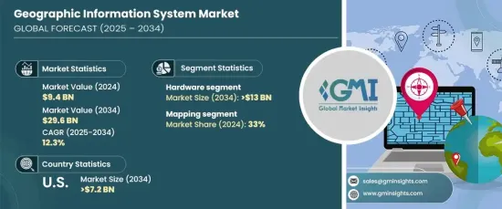
該市場由三個核心部分組成:硬體、軟體和服務。 2024 年,硬體領域佔據 46% 的主導佔有率,資料到 2034 年將創收 130 億美元。 GPS 系統、無人機、遙感技術和先進的測量儀器等設備對於擷取準確的地理空間資料至關重要,從而為 GIS 功能提供支援。對尖端硬體解決方案的持續需求凸顯了它們在滿足 GIS 市場不斷變化的需求方面的重要性。
| 市場範圍 | |
|---|---|
| 起始年份 | 2024 |
| 預測年份 | 2025-2034 |
| 起始值 | 94億美元 |
| 預測值 | 296億美元 |
| 複合年成長率 | 12.3% |
GIS 的應用多種多樣,涵蓋地圖繪製、測量、導航、遠端資訊處理和基於位置的服務。地圖繪製佔據了主導地位,佔據了 33% 的市場。這部分對於將原始地理空間資料轉換為可操作的格式(包括地圖、模型和圖表)至關重要。城市規劃、交通、農業和災害管理等領域都嚴重依賴地圖來提供決策基礎。對即時資料的需求不斷成長,加上智慧城市計畫的擴展,推動了對導航、基礎設施監控和緊急應變等高度準確和及時的地圖解決方案的需求。
美國在全球 GIS 市場佔據主導地位,2024 年的市佔率高達 81%。政府機構正在利用 GIS 進行環境監測、災害應變和土地管理等關鍵應用。主要供應商正在不斷創新地理空間技術,增強滿足不同產業需求的能力。預計到 2034 年美國 GIS 市場規模將超過 72 億美元,從而鞏固其作為全球成長和地理資訊系統技術進步的主要驅動力地位。
目錄
第 1 章:方法論與範圍
- 研究設計
- 研究方法
- 資料收集方法
- 基礎估計和計算
- 基準年計算
- 市場估計的主要趨勢
- 預測模型
- 初步研究與驗證
- 主要來源
- 資料探勘來源
- 市場定義
第 2 章:執行摘要
第 3 章:產業洞察
- 產業生態系統分析
- 硬體製造商
- 軟體供應商
- 數據供應商
- 系統整合商
- 最終用途
- 供應商概況
- 利潤率分析
- 技術與創新格局
- 重要新聞及舉措
- 監管格局
- 衝擊力
- 成長動力
- 都市化和基礎設施發展
- 技術進步
- 決策對地理空間資料的需求
- 氣候變遷與環境議題
- 產業陷阱與挑戰
- 初始成本和維護成本高
- 整合和互通性的複雜性
- 成長動力
- 成長潛力分析
- 波特的分析
- PESTEL 分析
第4章:競爭格局
- 介紹
- 公司市佔率分析
- 競爭定位矩陣
- 戰略展望矩陣
第5章:市場估計與預測:按組件,2021 - 2034 年
- 主要趨勢
- 硬體
- GIS 收集器
- GNSS 天線
- 全站儀
- LiDAR
- 軟體
- 桌面 GIS
- 網路地理資訊系統
- 行動 GIS
- 服務
- 培訓與諮詢
- 整合與維護
- 託管服務
第 6 章:市場估計與預測:按應用,2021 - 2034 年
- 主要趨勢
- 對應
- 測量
- 基於位置的服務
- 遠端資訊處理和導航
第 7 章:市場估計與預測:按最終用途,2021 - 2034 年
- 主要趨勢
- 農業
- 建造
- 礦業
- 石油和天然氣
- 電信
- 政府
- 運輸與物流
- 水管理
- 其他
第 8 章:市場估計與預測:按地區,2021 - 2034 年
- 主要趨勢
- 北美洲
- 美國
- 加拿大
- 歐洲
- 英國
- 德國
- 法國
- 西班牙
- 義大利
- 北歐
- 俄羅斯
- 亞太地區
- 中國
- 印度
- 日本
- 韓國
- 澳洲
- 東南亞
- 拉丁美洲
- 巴西
- 墨西哥
- 阿根廷
- 中東及非洲
- 阿拉伯聯合大公國
- 南非
- 沙烏地阿拉伯
第9章:公司簡介
- Autodesk
- Bentley Systems
- Blue Marble Geographics
- Caliper Corporation
- ESRI
- FME (Feature Manipulation Engine)
- GE Digital (Smallworld)
- GIS Cloud
- Global Mapper
- HERE Technologies
- Hexagon
- Mapbox
- MapInfo Professional
- Maxar Technologies
- Microsoft
- Orbital Insight
- Pitney Bowes
- SuperMap
- Topcon Positioning Systems
- Trimble
The Global Geographic Information System Market, valued at USD 9.4 billion in 2024, is poised for remarkable growth, with a projected CAGR of 12.3% from 2025 to 2034. This surge is fueled by increasing urbanization and the pressing demand for efficient urban planning, land management, and infrastructure monitoring. As cities expand and infrastructure projects become more complex, GIS technology is emerging as a critical tool for designing modern urban spaces, optimizing transportation networks, and managing utilities. By integrating spatial data with advanced analytics, GIS supports governments and organizations in addressing the growing challenges of urban development and sustainability. The technology's versatility extends beyond urban planning, offering solutions in agriculture, disaster management, and environmental monitoring, making it indispensable across various industries.
The market comprises three core components: hardware, software, and services. In 2024, the hardware segment held a dominant 46% share and is expected to generate USD 13 billion by 2034. Hardware is integral to the GIS ecosystem, as it provides the tools for data acquisition, processing, and visualization. Devices such as GPS systems, drones, remote sensing technologies, and advanced surveying instruments are pivotal in capturing accurate geospatial data, which powers GIS functionalities. This ongoing demand for cutting-edge hardware solutions underscores their importance in meeting the evolving needs of the GIS market.
| Market Scope | |
|---|---|
| Start Year | 2024 |
| Forecast Year | 2025-2034 |
| Start Value | $9.4 Billion |
| Forecast Value | $29.6 Billion |
| CAGR | 12.3% |
Applications of GIS are diverse and span mapping, surveying, navigation, telematics, and location-based services. Mapping leads the way, holding a substantial 33% market share. This segment is crucial for transforming raw geospatial data into actionable formats, including maps, models, and charts. Sectors like urban planning, transportation, agriculture, and disaster management rely heavily on mapping to inform decision-making. The rising need for real-time data, coupled with the expansion of smart city initiatives, is driving demand for highly accurate and timely mapping solutions for navigation, infrastructure monitoring, and emergency response.
The United States dominates the global GIS market, holding an impressive 81% share in 2024. This leadership is attributed to the country's robust technological infrastructure, significant investments in GIS by public and private sectors, and widespread adoption across industries. Government agencies are leveraging GIS for critical applications such as environmental monitoring, disaster response, and land management. Major providers are continuously innovating geospatial technologies, enhancing capabilities to meet diverse industry requirements. The U.S. GIS market is forecasted to exceed USD 7.2 billion by 2034, reinforcing its position as a key driver of global growth and technological advancements in geographic information systems.
Table of Contents
Chapter 1 Methodology & Scope
- 1.1 Research design
- 1.1.1 Research approach
- 1.1.2 Data collection methods
- 1.2 Base estimates and calculations
- 1.2.1 Base year calculation
- 1.2.2 Key trends for market estimates
- 1.3 Forecast model
- 1.4 Primary research & validation
- 1.4.1 Primary sources
- 1.4.2 Data mining sources
- 1.5 Market definitions
Chapter 2 Executive Summary
- 2.1 Industry synopsis, 2021 - 2034
Chapter 3 Industry Insights
- 3.1 Industry ecosystem analysis
- 3.1.1 Hardware manufacturers
- 3.1.2 Software vendors
- 3.1.3 Data vendors
- 3.1.4 System integrators
- 3.1.5 End use
- 3.2 Supplier landscape
- 3.3 Profit margin analysis
- 3.4 Technology & innovation landscape
- 3.5 Key news & initiatives
- 3.6 Regulatory landscape
- 3.7 Impact forces
- 3.7.1 Growth drivers
- 3.7.1.1 Urbanization and infrastructure development
- 3.7.1.2 Technological advancements
- 3.7.1.3 Demand for geospatial data in decision-making
- 3.7.1.4 Climate change and environmental concerns
- 3.7.2 Industry pitfalls & challenges
- 3.7.2.1 High initial costs and maintenance
- 3.7.2.2 Complexity in integration and interoperability
- 3.7.1 Growth drivers
- 3.8 Growth potential analysis
- 3.9 Porter’s analysis
- 3.10 PESTEL analysis
Chapter 4 Competitive Landscape, 2024
- 4.1 Introduction
- 4.2 Company market share analysis
- 4.3 Competitive positioning matrix
- 4.4 Strategic outlook matrix
Chapter 5 Market Estimates & Forecast, By Component, 2021 - 2034 ($Bn)
- 5.1 Key trends
- 5.2 Hardware
- 5.2.1 GIS collectors
- 5.2.2 GNSS antenna
- 5.2.3 Total station
- 5.2.4 LiDAR
- 5.3 Software
- 5.3.1 Desktop GIS
- 5.3.2 Web GIS
- 5.3.3 Mobile GIS
- 5.4 Service
- 5.4.1 Training & consulting
- 5.4.2 Integration & maintenance
- 5.4.3 Managed services
Chapter 6 Market Estimates & Forecast, By Application, 2021 - 2034 ($Bn)
- 6.1 Key trends
- 6.2 Mapping
- 6.3 Surveying
- 6.4 Location-based services
- 6.5 Telematics and navigation
Chapter 7 Market Estimates & Forecast, By End Use, 2021 - 2034 ($Bn)
- 7.1 Key trends
- 7.2 Agriculture
- 7.3 Construction
- 7.4 Mining
- 7.5 Oil & gas
- 7.6 Telecommunication
- 7.7 Government
- 7.8 Transportation & logistics
- 7.9 Water management
- 7.10 Others
Chapter 8 Market Estimates & Forecast, By Region, 2021 - 2034 ($Bn)
- 8.1 Key trends
- 8.2 North America
- 8.2.1 U.S.
- 8.2.2 Canada
- 8.3 Europe
- 8.3.1 UK
- 8.3.2 Germany
- 8.3.3 France
- 8.3.4 Spain
- 8.3.5 Italy
- 8.3.6 Nordics
- 8.3.7 Russia
- 8.4 Asia Pacific
- 8.4.1 China
- 8.4.2 India
- 8.4.3 Japan
- 8.4.4 South Korea
- 8.4.5 Australia
- 8.4.6 Southeast Asia
- 8.5 Latin America
- 8.5.1 Brazil
- 8.5.2 Mexico
- 8.5.3 Argentina
- 8.6 MEA
- 8.6.1 UAE
- 8.6.2 South Africa
- 8.6.3 Saudi Arabia
Chapter 9 Company Profiles
- 9.1 Autodesk
- 9.2 Bentley Systems
- 9.3 Blue Marble Geographics
- 9.4 Caliper Corporation
- 9.5 ESRI
- 9.6 FME (Feature Manipulation Engine)
- 9.7 GE Digital (Smallworld)
- 9.8 GIS Cloud
- 9.9 Global Mapper
- 9.10 HERE Technologies
- 9.11 Hexagon
- 9.12 Mapbox
- 9.13 MapInfo Professional
- 9.14 Maxar Technologies
- 9.15 Microsoft
- 9.16 Orbital Insight
- 9.17 Pitney Bowes
- 9.18 SuperMap
- 9.19 Topcon Positioning Systems
- 9.20 Trimble
 全球地理資訊系統市場:市場規模、佔有率、趨勢分析(按設備、組件、應用、行業和地區)、展望和未來預測(2024-2031 年)
 全球自然災害管理市場按組件、應用、最終用戶、通訊系統和地區分類 - 預測至 2029 年
 2025年地理資訊系統(GIS)軟體全球市場報告
 2025 年至 2033 年電信業 GIS 市場報告,按類型(軟體、服務)、部署模式(基於雲端、本地)、最終用戶(大型企業、中小型企業 (SME))和地區分類2025 年地理資訊系統全球市場報告
 2025-2029 年全球 GIS 市場GIS 控制器市場 - 全球產業規模、佔有率、趨勢、機會和預測,按組件、設備、應用、地區、競爭細分 2020-2030F2025-2033 年按組件、功能、設備、最終用途行業和地區分類的地理資訊系統市場報告
 地理資訊系統-市場佔有率分析、產業趨勢與統計、成長趨勢預測(2025-2030)
 公共產業產業的全球 GIS 市場(2025-2029)