


 |
市場調查報告書
商品編碼
1643022
地理資訊系統-市場佔有率分析、產業趨勢與統計、成長趨勢預測(2025-2030)Geographic Information System - Market Share Analysis, Industry Trends & Statistics, Growth Forecasts (2025 - 2030) |
||||||
※ 本網頁內容可能與最新版本有所差異。詳細情況請與我們聯繫。
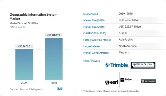
地理資訊系統市場規模預計在 2025 年為 945.9 億美元,預計到 2030 年將達到 1,288.7 億美元,預測期內(2025-2030 年)的複合年成長率為 6.38%。
地理資訊系統 (GIS) 市場正在發展成為跨行業的關鍵技術,利用空間資料來增強決策流程。 GIS 使組織能夠捕獲、儲存、分析和視覺化地理訊息,這使其對於城市規劃、基礎設施管理和環境監測等應用具有重要意義。智慧城市的興起和地理空間資料的進步正在推動 GIS 在農業、公共和建築等領域的廣泛應用。
GIS 市場關鍵基本面
關鍵亮點
- 與現代商業的相關性增強:GIS 市場因融入商業環境而顯著成長。政府和私人公司都在大力投資 GIS 技術,以最佳化業務、改善服務交付並促進永續發展。此外,硬體和軟體的進步也提高了 GIS 工具的準確性和易用性。例如,雲端基礎的GIS 提供可擴展性和協作功能,有助於產業向資料主導解決方案的轉變。
- 與新技術的整合:GIS 市場因其與人工智慧 (AI) 和物聯網 (IoT) 等其他技術整合的能力而不斷擴大。這種融合實現了即時資料收集和預測分析,刺激了各行業的需求。區域分析系統解決方案代表了地理空間智慧的突破,突破了資料分析和空間映射創新的界限。
- 資料品質和舊有系統整合挑戰:雖然 GIS 的應用正在成長,但資料品質和與舊有系統的整合等挑戰阻礙了某些地區的無縫推廣。組織必須對資料準確性和基礎設施現代化進行投資,以克服這些障礙,並確保其 GIS 解決方案能夠滿足對準確空間資料日益成長的需求。
智慧城市中 GIS 的應用
關鍵亮點
- 在都市規劃中的關鍵角色:隨著都市化的加速,GIS 成為智慧城市發展的核心。城市負責人使用 GIS 來管理基礎設施、最佳化交通網路並提高公共安全。 GIS 處理大量空間資料並提取見解以改善城市管理和資源分配。
- 基礎設施最佳化 GIS 協助城市規劃者繪製資源、土地使用和基礎設施開發圖,以支援永續的城市設計。
- 即時監控:透過即時資料饋送,GIS 可以監控能源消耗、交通模式和緊急應變,以簡化城市運作。
- 數位雙胞胎:GIS 支援創建數位雙胞胎(模擬城市發展的虛擬城市模型),以便在變化實際實施之前預測其影響。
整合 GIS 與商業智慧
關鍵亮點
- 轉變商業分析:GIS 市場最重要的趨勢之一是與商業智慧(BI) 工具的整合。透過這種整合,企業能夠將基於位置的資料與績效指標疊加,以更深入地了解客戶行為、市場機會和供應鏈效率。
- 資料的地理視覺化:透過將 GIS 與 BI 工具結合,可以將業務資料進行地理視覺化,從而為效率提供新的觀點。
- 產業特定優勢:零售、物流和通訊等行業可以從 GIS 中受益,以最佳化資源配置、改善市場策略並推動客戶參與。
- 預測分析:將 GIS 與預測分析結合使用,公司可以預測需求趨勢、確定高潛力區域、降低風險並增強決策流程。
與現有系統整合的挑戰
關鍵亮點
- 同步複雜性:將 GIS 與傳統企業系統(例如企業資源規劃 (ERP) 和客戶關係管理 (CRM) 平台)整合可能很複雜,尤其是對於依賴傳統技術的公司而言。
- 舊有系統:許多組織努力使其 GIS 與過時的資料管理平台保持同步,導致業務效率低落。
- 需要大量投資:成功採用 GIS 通常需要在軟體升級和員工培訓方面進行大量投資。
- 資料重複的風險:傳統資料庫與現代 GIS 解決方案之間的不匹配可能導致資料重複和錯誤,從而削弱空間資訊的價值。
對資料品質和準確性的擔憂
關鍵亮點
- 高品質資料的重要性:為了使 GIS 應用程式提供準確的見解,輸入的資料必須滿足高品質和準確性的標準。然而,資料準確性仍然是許多用戶關心的問題,特別是在農業、建築和運輸領域,空間資料中的錯誤可能會帶來代價高昂的後果。
- 資料收集不一致:不準確的 GIS 分析通常是由於資料收集方法不一致或資料集過時所造成的。
- 開發中地區面臨的挑戰:在開發中地區,由於無法取得先進的資料收集工具,GIS資料的品質受到進一步損害。
- 提高準確性的挑戰:對高解析度衛星影像、即時資料擷取技術和強大的資料檢驗流程的投資對於解決這些資料品質挑戰至關重要。
地理資訊系統 (GIS) 市場趨勢
新興市場的發展和城市規劃正在推動市場成長
- 智慧城市推動 GIS 市場成長智慧城市的興起和先進的城市規劃需求是 GIS 市場的主要驅動力。智慧城市依靠 GIS 技術來有效管理基礎設施、資源和基本服務,這反映了對支援城市擴張和規劃的技術日益成長的需求。
- 基礎設施和資源管理:GIS 對於管理交通、能源和供水等城市系統至關重要,有助於 GIS 市場的成長。
- 城市設計的永續性:城市負責人使用 GIS 透過最佳化土地利用、監測交通、評估人口趨勢等來開發永續、宜居的城市。
- 利用 GIS 技術增強決策能力:政府和城市開發商使用 GIS 分析空間資料以做出明智的決策,尤其是在基礎設施開發和環境風險管理方面。對 GIS 的依賴對於應對快速都市化和永續發展的挑戰至關重要。
亞太地區市場成長最高
- 快速都市化和政府舉措:由於快速都市化、政府投資和技術進步,預計亞太地區將見證 GIS 市場的最高成長。中國和印度等國家在採用 GIS 方面處於領先地位,尤其是透過其智慧城市計畫和基礎設施發展計劃。
- 政府支持的計劃:印度的「數位印度」和中國的「智慧城市」計畫等措施正在加速 GIS 在城市規劃和災害管理等領域的整合。
- 關鍵產業應用:GIS 廣泛應用於亞太地區的農業、交通和公共工程,對該地區 GIS 市場的整體成長做出了重大貢獻。
- GIS 創新:人工智慧和物聯網等新技術進一步推動亞太地區 GIS 的應用,提供更精確的地理空間資料和分析。隨著政府和企業對 GIS 的大力投資,預計未來幾年市場規模將穩定上升。
地理資訊系統 (GIS) 產業概況
地理資訊系統市場:GIS 市場適度整合,Autodesk Inc.、Bentley Systems 和 Hexagon AB 等主導參與企業引領創新與應用。儘管少數大公司佔據主導地位,但區域競爭對手和利基市場參與企業正在尋找機會提供特定產業的解決方案。
技術領導:Hexagon AB、Pitney Bowes Inc.等主要企業透過廣泛的全球營運和多樣化的產品系列保持領先地位,並持續推動人工智慧、雲端運算和巨量資料領域的研發。
客製化和夥伴關係:領先的公司專注於創新和客製化以滿足特定行業的需求,並與政府和其他行業夥伴關係以擴大其市場範圍。
其他福利
- Excel 格式的市場預測 (ME) 表
- 3 個月的分析師支持
目錄
第 1 章 簡介
- 研究假設和市場定義
- 研究範圍
第2章調查方法
第3章執行摘要
第4章 市場動態
- 市場概況
- 產業吸引力-波特五力分析
- 供應商的議價能力
- 買家的議價能力
- 新進入者的威脅
- 替代品的威脅
- 競爭對手之間的競爭
- 市場促進因素
- GIS 在智慧城市生態系中的作用不斷擴大
- 整合地理位置地圖和商業智慧系統
- 市場限制
- 與遺留系統整合的問題
- 資料品質和準確性問題
- COVID-19 工業影響評估
第5章 市場區隔
- 按組件
- 硬體
- 軟體
- 按功能
- 製圖
- 測量
- 遠端資訊處理和導航
- 定位服務
- 按最終用戶
- 農業
- 公共工程
- 礦業
- 建造
- 運輸
- 石油和天然氣
- 按地區
- 北美洲
- 歐洲
- 亞洲
- 澳洲和紐西蘭
- 拉丁美洲
- 中東和非洲
第6章 競爭格局
- 公司簡介
- Trimble Inc.
- Spatialworks
- Geosoft
- ESRI Inc.
- Caliper Corporation
- Topcon Positioning Systems
- Pitney Bowes Inc.
- Hexagon AB
- Bentley Systems
- Autodesk Inc.
第7章投資分析
第8章 市場機會與未來趨勢
The Geographic Information System Market size is estimated at USD 94.59 billion in 2025, and is expected to reach USD 128.87 billion by 2030, at a CAGR of 6.38% during the forecast period (2025-2030).
The Geographic Information System (GIS) market has evolved into a critical technology across industries, leveraging spatial data to enhance decision-making processes. GIS allows organizations to capture, store, analyze, and visualize geographic information, making it invaluable for applications in urban planning, infrastructure management, and environmental monitoring. The rise of smart cities and advancements in geospatial data have significantly expanded the adoption of GIS in sectors such as agriculture, utilities, and construction.
Key Fundamentals of the GIS Market
Key Highlights
- Increased Relevance in Modern Business: The GIS market has grown significantly due to its integration into business environments. Both governments and private enterprises are investing heavily in GIS technologies to optimize operations, improve service delivery, and drive sustainable development. Additionally, advances in hardware and software have enhanced the precision and usability of GIS tools. For instance, cloud-based GIS offers scalability and collaborative features, contributing to the industry's shift toward data-driven solutions.
- Integration with Emerging Technologies: The GIS market is expanding due to its ability to integrate with other technologies like Artificial Intelligence (AI) and the Internet of Things (IoT). This convergence allows for real-time data collection and predictive analytics, spurring demand across industries. Geographic information system solutions have seen significant advancements in geospatial intelligence, pushing the boundaries of innovation in data analysis and spatial mapping.
- Challenges in Data Quality and Legacy System Integration: While GIS adoption is growing, challenges like data quality and the integration of GIS with legacy systems hinder seamless deployment in some regions. Organizations need to invest in data accuracy and infrastructure modernization to overcome these barriers, ensuring that GIS solutions meet the growing demand for precise spatial data.
Adoption of GIS in Smart Cities
Key Highlights
- Essential Role in Urban Planning: As urbanization accelerates, GIS has become central to smart city development. Urban planners use GIS to manage infrastructure, optimize transportation networks, and enhance public safety. GIS processes vast amounts of spatial data, providing insights that improve city management and resource allocation.
- Infrastructure Optimization: GIS aids urban planners in mapping resources, land use, and infrastructure development, supporting sustainable city designs.
- Real-Time Monitoring: Through real-time data feeds, GIS monitors energy consumption, traffic patterns, and emergency responses, streamlining city operations.
- Digital Twins: GIS supports the creation of digital twins, virtual city models that simulate urban developments, predicting the impact of changes before physical implementation.
Integration of GIS with Business Intelligence
Key Highlights
- Transforming Business Analytics: One of the most significant trends in the GIS market is its integration with Business Intelligence (BI) tools. This convergence enables businesses to layer location-based data with performance metrics, generating deeper insights into customer behavior, market opportunities, and supply chain efficiencies.
- Geographical Visualization of Data: Integrating GIS with BI tools allows businesses to visualize operational data geographically, offering new perspectives on efficiency.
- Industry-Specific Benefits: Sectors like retail, logistics, and telecommunications benefit from GIS, optimizing resource allocation, improving market strategies, and driving customer engagement.
- Predictive Analytics: Businesses can use GIS with predictive analytics to anticipate demand trends, identify high-potential regions, and mitigate risks, enhancing decision-making processes.
Integration Challenges with Traditional Systems
Key Highlights
- Complexity in Synchronization: Integrating GIS with traditional enterprise systems, such as enterprise resource planning (ERP) or customer relationship management (CRM) platforms, can be complex, especially for organizations relying on outdated technology.
- Legacy Systems: Many organizations struggle to synchronize GIS with older data management platforms, leading to operational inefficiencies.
- Significant Investments Needed: Integration often requires substantial investments in software upgrades and personnel training to ensure smooth GIS adoption.
- Data Duplication Risks: Misalignment between traditional databases and modern GIS solutions can result in data duplication or errors, compromising the value of spatial information.
Data Quality and Accuracy Concerns
Key Highlights
- The Importance of High-Quality Data: For GIS applications to deliver accurate insights, the data inputted must meet high standards of quality and precision. However, data accuracy remains a concern for many users, especially in agriculture, construction, and transportation, where errors in spatial data can lead to costly consequences.
- Inconsistent Data Collection: Inaccurate GIS analysis often stems from inconsistent data collection methods or outdated datasets.
- Challenges in Developing Regions: In developing regions, access to advanced data-gathering tools is limited, further compromising the quality of GIS data.
- Solutions for Improved Accuracy: Investments in high-resolution satellite imagery, real-time data acquisition technologies, and robust data validation processes are crucial for addressing these data quality challenges.
Geographic Information System (GIS) Market Trends
The Rising Smart Cities Development and Urban Planning to Drive the Market Growth
- Smart Cities Drive GIS Market Growth: The rise of smart cities and advanced urban planning needs are key drivers of the GIS market. Smart cities depend on GIS technology to efficiently manage infrastructure, resources, and essential services, reflecting the increasing demand for technology that supports urban expansion and planning.
- Infrastructure and Resource Management: GIS is essential for managing urban systems like transportation, energy, and water supply, contributing to the growth of the GIS market.
- Sustainability in Urban Design: Urban planners use GIS to develop sustainable, livable cities by optimizing land use, monitoring traffic, and assessing demographic trends.
- Enhanced Decision-Making with GIS Technology: Governments and urban developers use GIS to analyze spatial data for informed decision-making, particularly in infrastructure development and environmental risk management. This reliance on GIS is essential in addressing the challenges of rapid urbanization and sustainable development.
Asia-Pacific to Register Highest Market Growth
- Rapid Urbanization and Government Initiatives: The Asia-Pacific region is expected to experience the highest growth in the GIS market due to rapid urbanization, government investments, and technological advancements. Countries like China and India lead GIS adoption, particularly through smart city initiatives and infrastructure development projects.
- Government-Backed Projects: Initiatives like India's Digital India and China's smart city programs are accelerating GIS integration in sectors such as urban planning and disaster management.
- Key Industry Applications: GIS is widely used in agriculture, transportation, and utilities in the Asia-Pacific, contributing significantly to the region's overall GIS market growth.
- Technological Innovation in GIS: Emerging technologies like AI and IoT are further driving GIS adoption in Asia-Pacific, delivering more accurate geospatial data and analytics. With governments and enterprises investing heavily in GIS, the market value is set to climb steadily in the coming years.
Geographic Information System (GIS) Industry Overview
Semi-Consolidated Market: The GIS market is moderately consolidated, with dominant players like Autodesk Inc., Bentley Systems, and Hexagon AB leading innovation and adoption. While a few large companies dominate, regional competitors and niche players still find opportunities to offer industry-specific solutions.
Technological Leadership: Companies like Hexagon AB and Pitney Bowes Inc. lead through extensive global operations and diverse product portfolios, continuously driving R&D efforts in AI, cloud computing, and big data.
Customization and Partnerships: Industry leaders focus on innovation and customization to meet specific sector needs, forming partnerships with governments and other industries to expand market reach.
Additional Benefits:
- The market estimate (ME) sheet in Excel format
- 3 months of analyst support
TABLE OF CONTENTS
1 INTRODUCTION
- 1.1 Study Assumptions and Market Definition
- 1.2 Scope of the Study
2 RESEARCH METHODOLOGY
3 EXECUTIVE SUMMARY
4 MARKET DYNAMICS
- 4.1 Market Overview
- 4.2 Industry Attractiveness - Porter's Five Forces Analysis
- 4.2.1 Bargaining Power of Suppliers
- 4.2.2 Bargaining Power of Buyers
- 4.2.3 Threat of New Entrants
- 4.2.4 Threat of Substitutes
- 4.2.5 Intensity of Competitive Rivalry
- 4.3 Market Drivers
- 4.3.1 Growing role of GIS in Smart Cities Ecosystem
- 4.3.2 Integration of Location-based Mapping Systems with Business Intelligence Systems
- 4.4 Market Restraints
- 4.4.1 Integration Issues with Traditional Systems
- 4.4.2 Data Quality and Accuracy Issues
- 4.5 Assessment of Impact of COVID-19 on the Industry
5 MARKET SEGMENTATION
- 5.1 By Component
- 5.1.1 Hardware
- 5.1.2 Software
- 5.2 By Function
- 5.2.1 Mapping
- 5.2.2 Surveying
- 5.2.3 Telematics and Navigation
- 5.2.4 Location-based Services
- 5.3 By End User
- 5.3.1 Agriculture
- 5.3.2 Utilities
- 5.3.3 Mining
- 5.3.4 Construction
- 5.3.5 Transportation
- 5.3.6 Oil and Gas
- 5.4 By Geography
- 5.4.1 North America
- 5.4.2 Europe
- 5.4.3 Asia
- 5.4.4 Australia and New Zealand
- 5.4.5 Latin America
- 5.4.6 Middle East and Africa
6 COMPETITIVE LANDSCAPE
- 6.1 Company Profiles
- 6.1.1 Trimble Inc.
- 6.1.2 Spatialworks
- 6.1.3 Geosoft
- 6.1.4 ESRI Inc.
- 6.1.5 Caliper Corporation
- 6.1.6 Topcon Positioning Systems
- 6.1.7 Pitney Bowes Inc.
- 6.1.8 Hexagon AB
- 6.1.9 Bentley Systems
- 6.1.10 Autodesk Inc.
7 INVESTMENT ANALYSIS
8 MARKET OPPORTUNITIES AND FUTURE TRENDS
 全球地理資訊系統市場:市場規模、佔有率、趨勢分析(按設備、組件、應用、行業和地區)、展望和未來預測(2024-2031 年)
 全球自然災害管理市場按組件、應用、最終用戶、通訊系統和地區分類 - 預測至 2029 年
 2025年地理資訊系統(GIS)軟體全球市場報告
 2025 年至 2033 年電信業 GIS 市場報告,按類型(軟體、服務)、部署模式(基於雲端、本地)、最終用戶(大型企業、中小型企業 (SME))和地區分類2025 年地理資訊系統全球市場報告
 2025-2029 年全球 GIS 市場GIS 控制器市場 - 全球產業規模、佔有率、趨勢、機會和預測,按組件、設備、應用、地區、競爭細分 2020-2030F2025-2033 年按組件、功能、設備、最終用途行業和地區分類的地理資訊系統市場報告
 公共產業產業的全球 GIS 市場(2025-2029)
 地理資訊系統市場機會、成長動力、產業趨勢分析與預測 2025 - 2034