


 |
市場調查報告書
商品編碼
1637781
亞太地區雷射雷達:市場佔有率分析、產業趨勢與統計、成長預測(2025-2030 年)Asia Pacific LiDAR - Market Share Analysis, Industry Trends & Statistics, Growth Forecasts (2025 - 2030) |
||||||
※ 本網頁內容可能與最新版本有所差異。詳細情況請與我們聯繫。
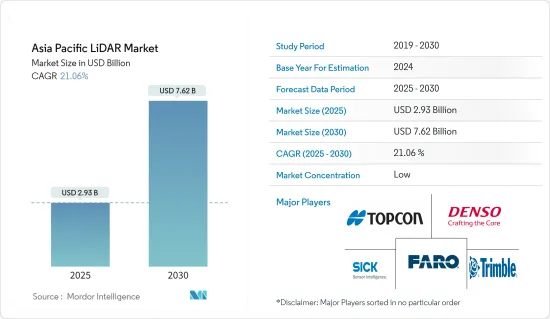
亞太地區 LiDAR 市場規模預計在 2025 年為 29.3 億美元,預計到 2030 年將達到 76.2 億美元,預測期內(2025-2030 年)的複合年成長率為 21.06%。
基於 LiDAR 的地圖測繪解決方案非常靈活,可用於固定和移動車輛。這使得越來越多的行業採用該技術,特別是在工程、建築、環境和探勘應用領域,證明了該技術的有效性和需求。
主要亮點
- 這些LiDAR也用於實地宣傳活動規劃和森林座艙罩測繪。西班牙科學家利用雷射雷達資料提高了年度和季節性測繪精度(從 73% 提高到 83%)。此外,LiDAR 市場的另一個主要驅動力是無人機在航太、國防和自動化等多種應用領域的應用日益廣泛,這促使各組織對無人機研究進行投資。
- 在該地區,雷射雷達系統與無人機的應用也正在國防、地質勘測、污染監測、交通、能源和建築領域部署。此外,預測期內印度和中國等國家預計將加快對國防無人機技術的投資,平均投資額將增加 70 億美元。
- 在馬來西亞,政府正在使用雷射雷達繪製水位深度、沿海地區的洪水風險以及運河堵塞修復要求。該地區各國政府擴大採用 LiDAR 系統,預計將對預測期內的市場成長產生積極貢獻。
- 日本三菱電機公司推出了一種用於自動駕駛汽車的緊湊型 LiDAR 解決方案,體積約為 900cc,採用 MEMS 技術,可增強自動駕駛汽車的水平視野範圍和行人偵測能力。該公司還計劃開發體積僅為 350cc 或更小的緊湊型 LiDAR。
- 此外,新冠肺炎疫情導致世界各地實施封鎖。這擾亂了汽車零件的製造過程和出口。此外,系統昂貴的特性也為這些系統的採用帶來了挑戰。福特和百度等公司正在投資這些系統,以開發低成本的LiDAR系統。
亞太地區 LiDAR 市場趨勢
地面LiDAR預計將實現最高成長
- 地面雷射雷達系統廣泛應用於近距離和高精度應用,尤其是建築修復、設施清單、侵蝕測繪、穩定性檢測以及製造業的各種應用。靜態和動態變化經常與 GPS 參考技術一起納入探勘、工程和其他移動式製圖系統中,以提高精度和準確度。
- 地面固定雷射雷達成本相對較低,因此這些設備可以避免在機載系統和車載雷射雷達掃描器中使用 IMU。這些特性使得地面雷射雷達在工業、緊急和災害管理以及發生不良事件時的測繪方面具有成本效益。
- 地面雷射雷達系統的低成本,加上較不嚴格的測繪和測量法規,預計將推動該領域的成長。
- 可以使用地面雷射掃描(TLS)資料中的高解析度積雪/土壤深度和積雪/土壤深度變化圖來量化雪崩/山體滑坡多發地區的雪崩/山體滑坡負荷模式。
- 在該地區,汽車產業正在成為移動地面雷射雷達系統的一個應用領域。根據印度公路運輸和公路部的規定,到2022年,所有新車(包括大型車輛)都必須配備ADAS系統。因此,政府的這些舉措必將支持該市場的成長。
航太和國防工業的不斷發展預計將推動市場成長
- LiDAR 在航太和國防工業的應用有限。儘管如此,仍有研究潛力確定 LiDAR 技術在國防工業的應用範圍。在國防工業中,使用無人機監視未開發區域至關重要,而使用 LiDAR 技術透過障礙物分析資料對於識別異常起著關鍵作用。
- 正在開發用於水雷戰的機載雷射水雷探測系統 (ALMDS) 等更高解析度的系統,以收集更多細節,從而識別目標並穿越森林冠層和其他障礙物。短程雷射雷達用於識別危險區域中氣體、液體和其他生物威脅的存在。
- 憑藉快速檢測和即時響應的能力,LiDAR 技術比工業中實施的其他傳統技術具有關鍵優勢。
- 此外,各種政府措施也影響該市場的成長。例如,印度政府計劃對東北各州的所有道路進行雷射雷達勘測。這也可能有助於促進該市場的本地供應商的發展。
- 由於 LiDAR 系統在國防、地質勘測、能源和建築領域的廣泛應用,預計印度和中國等各國在預測期內將在國防無人機技術上平均投資 70 億美元。
亞太地區LiDAR產業概況
由於亞太地區有許多參與者,因此該地區的 LiDAR 市場競爭非常激烈。大多數主要供應商都對其研發部門投入了大量資金,以獨樹一幟,區別於其他競爭對手。該市場的主要供應商包括 Topcon Corporation、Denso Corporation 和 Leishen Intelligent Systems。
- 2022 年 9 月 - Hexagon 的子公司 Leica Geosystems 推出了 Leica DMC-4,這是一款有效的機載成像感測器,可提供無與倫比的影像質量,可用於具有挑戰性的測繪場景。此合作關係可為客戶提供適用於各種應用的靈活、有效的大尺寸解決方案。
- 2022 年 1 月-YellowScan 與監測設備供應商 EcoTech Ltd. 合作。透過此次合作,Ecotech 將擴大其在生態系統監測、林業、農業、測繪和測量等領域的研究和應用。該業務還將迎合中國市場。
其他福利:
- Excel 格式的市場預測 (ME) 表
- 3 個月的分析師支持
目錄
第 1 章 簡介
- 研究假設和市場定義
- 研究範圍
第2章調查方法
第3章執行摘要
第4章 市場洞察
- 產業吸引力-波特五力分析
- 新進入者的威脅
- 買家的議價能力
- 供應商的議價能力
- 替代品的威脅
- 競爭對手之間的競爭強度
- 產業價值鏈分析
- COVID-19 市場影響
第5章 市場動態
- 市場促進因素
- 擴大在政府部門的應用
- 汽車業採用率不斷提高
- 市場限制
- LiDAR 系統高成本
第6章 市場細分
- 按產品
- 機載LiDAR
- 地面LiDAR
- 按組件
- GPS
- 雷射掃描儀
- 慣性測量單元
- 其他組件
- 按最終用戶
- 工程
- 車
- 工業的
- 航太和國防
第7章 競爭格局
- 公司簡介
- Leica Geosystems AG
- Topcon Corporation
- Neptec Technologies Corp.
- Sick AG
- Trimble Inc.
- Denso Corporation
- Faro Technologies Inc.
- Hesai Technology
- Benewake
- RoboSense LiDAR
- Leishen Intelligent Systems
第8章投資分析
第9章:市場的未來
The Asia Pacific LiDAR Market size is estimated at USD 2.93 billion in 2025, and is expected to reach USD 7.62 billion by 2030, at a CAGR of 21.06% during the forecast period (2025-2030).
LiDAR-based mapping solutions are agile and can be used on a stationary or moving vehicle. Owing to this, they are being adopted by a growing number of industries, especially for application in engineering, construction, environment, and exploration, proving the effectiveness and, therefore, demand for this technology.
Key Highlights
- These LiDARs are also used for the planning of field campaigns and mapping under the forest canopy. Spain-based scientists improved the annual and seasonal mapping accuracy with LiDAR data (from 73% to 83%). Moreover, another major driving factor for the LiDAR market is the increasing use of drones for multiple applications, such as aerospace and defense and automation, which are leading organizations to invest in drone research.
- In this region, LiDAR system applications are also being deployed in defense, geological surveys, pollution monitoring, transport, energy, and construction sectors, coupled with drones. Additionally, countries such as India and China are expected to increase, speeding an average of USD 7 billion in drone technology for defense in the forecast period.
- In Malaysia, the government has been using LiDAR to map the water table depth, flood risk in coastal areas, and canal-blocking restoration requirements. The increase in such adoption of LiDAR systems by governments across different countries in the region is expected to positively contribute to the market's growth over the forecast period.
- Japan's Mitsubishi Electric Corporation unveiled a new compact LiDAR solution for autonomous vehicles, equipped with MEMS that can enhance the horizontal vision span and pedestrian detection capabilities of the self-driving vehicle, with a volume of around 900cc. The company is also planning to develop a smaller LiDAR variant with a volume of just 350cc or less.
- Furthermore, the COVID-19 pandemic led to lockdowns all over the world. This disrupted the exports of automotive parts as well as the manufacturing process. Moreover, the expensive nature of the systems is challenging the adoption of these systems. Companies such as Ford and Baidu were investing in these systems to develop low-cost LiDAR systems.
APAC LiDAR Market Trends
Ground-based LiDAR Expected to Witness The Highest Growth
- The ground-based LiDAR systems have been widely used in close-range and high accuracy applications, especially in architectural restoration, facilities inventory, erosion mapping, stability detection, and various applications in the manufacturing industry. Static and dynamic variations are frequently incorporated in the exploration, engineering, and other mobile mapping systems, along with the GPS referencing techniques for precision and accuracy.
- The ground-based fixed LiDARs are relatively less costly, as these devices can avoid the use of IMU in air-borne systems or LiDAR scanners mounted on vehicles. Such features make the use of ground-based LiDAR cost-effective for the industries and can do the mapping in case of emergency and disaster management, in case of occurrence of any unwanted events.
- low costs associated with ground-based LiDAR systems, coupled with lesser stringent regulations for mapping or survey, are expected to drive the growth of this segment.
- High-resolution snow/soil depth and snow/soil depth change maps can be used from terrestrial laser scanning (TLS) data to quantify loading patterns of avalanche/landslides, in snow/landslide-prone regions, for use in both pre-control plannings and in post-control assessment in case of such events, which increases the application base of such products suitable to a diverse base of end-users.
- The automotive sector is emerging as an application area for mobile ground-based LiDAR systems within this region. According to the Ministry of Road Transport and Highways of India, the installation of the ADAS system is mandatory in all new vehicles (heavy-duty included) by 2022. Hence these types of government initiatives will definitely support the growth of this market.
Growing Aerospace and Defense Industry Expected to Drive Market Growth
- LiDAR has made limited leeway in the aerospace and defense industry. Still, there is potential for research to determine the extent of usage of LiDAR technology in the defense industry. The use of drones to monitor unexplored territory is crucial in the defense industry, and the use of LiDAR technology to analyze data through obstacles plays a vital role in identifying anomalies.
- Higher resolution systems are deployed to collect details to identify targets and movement through the forest canopies and other obstacles, such as Airborne Laser Mine Detection System (ALMDS) for the counter-mine warfare. Short-range LiDARs are utilized for identifying the presence of gases and liquids and other bio-threats in hazardous locations.
- The ability to detect rapidly and respond in real-time gives the LiDAR technology a significant edge over the other conventional technologies which have been implemented in the industry
- Moreover, different government initiatives are also influencing the growth of this market. For instance, The Indian government is also planning to carry LiDAR surveys for all the roads in the northeastern states. It will also help to promote the local providers for this market.
- Owing to the extensive use of the LiDAR system in defense, geological surveys, and energy and construction sectors, different countries such as India and China, are expected to increase speeding an average of USD 7 billion in drone technology for defense in the forecast period.
APAC LiDAR Industry Overview
The Asia Pacific Lidar market is highly competitive due to the presence of many players within this region. Most major vendors invest heavily in their research and development sections to create a unique differentiation from their other competitors. Some major vendors for this market are Topcon Corporation, Denso Corporation, Leishen Intelligent Systems, etc.
- September 2022 - Hexagon subsidiary Leica Geosystems revealed the Leica DMC-4, an effective airborne imaging sensor that offers unmatched image quality for use in challenging mapping scenarios. Customers would gain from this collaboration by receiving a flexible and effective large-format solution for a range of application uses.
- January 2022 - A provider of monitoring devices, EcoTech Ltd., and YellowScan have partnered. The business would expand its study and applications in ecological monitoring, forestry, agriculture, mapping, and surveying through this partnership. The business would also cater to the China market.
Additional Benefits:
- The market estimate (ME) sheet in Excel format
- 3 months of analyst support
TABLE OF CONTENTS
1 INTRODUCTION
- 1.1 Study Assumptions and Market Definition
- 1.2 Scope of the Study
2 RESEARCH METHODOLOGY
3 EXECUTIVE SUMMARY
4 MARKET INSIGHTS
- 4.1 Industry Attractiveness - Porter's Five Forces Analysis
- 4.1.1 Threat of New Entrants
- 4.1.2 Bargaining Power of Buyers
- 4.1.3 Bargaining Power of Suppliers
- 4.1.4 Threat of Substitute Products
- 4.1.5 Intensity of Competitive Rivalry
- 4.2 Industry Value Chain Analysis
- 4.3 Impact of COVID-19 on the Market
5 MARKET DYNAMICS
- 5.1 Market Drivers
- 5.1.1 Growing Applications in the Government Sector
- 5.1.2 Increasing Adoption in the Automotive Industry
- 5.2 Market Restraints
- 5.2.1 High Cost of the LiDAR Systems
6 MARKET SEGMENTATION
- 6.1 Product
- 6.1.1 Aerial LiDAR
- 6.1.2 Ground-based LiDAR
- 6.2 Components
- 6.2.1 GPS
- 6.2.2 Laser Scanners
- 6.2.3 Inertial Measurement Unit
- 6.2.4 Other Components
- 6.3 End User
- 6.3.1 Engineering
- 6.3.2 Automotive
- 6.3.3 Industrial
- 6.3.4 Aerospace and Defense
7 COMPETITIVE LANDSCAPE
- 7.1 Company Profiles
- 7.1.1 Leica Geosystems AG
- 7.1.2 Topcon Corporation
- 7.1.3 Neptec Technologies Corp.
- 7.1.4 Sick AG
- 7.1.5 Trimble Inc.
- 7.1.6 Denso Corporation
- 7.1.7 Faro Technologies Inc.
- 7.1.8 Hesai Technology
- 7.1.9 Benewake
- 7.1.10 RoboSense LiDAR
- 7.1.11 Leishen Intelligent Systems
8 INVESTMENT ANALYSIS
9 FUTURE OF THE MARKET
 2025 年 LiDAR 全球市場報告
 LiDAR:全球市場佔有率分析、行業趨勢和統計、成長預測(2025-2030 年)
 北美 LiDAR:市場佔有率分析、行業趨勢和成長預測(2025-2030 年)
 歐洲雷射雷達:市場佔有率分析、產業趨勢/統計、成長預測(2025-2030)
 LiDAR技術的全球市場:市場佔有率排行榜,整體銷售額與需求預測(2024年~2030年)
 2025-2033 年日本LiDAR市場報告(按安裝類型、組件、應用和地區)
 LiDAR 市場:按技術、組件、服務、類型和最終用途分類 - 2025-2030 年全球預測
 全球LiDAR市場評估:安裝區分·零組件·類型·距離·用途·各地區的機會及預測 (2017-2031年)
 地形與天氣 LiDAR 市場報告:2030 年趨勢、預測與競爭分析
 LiDAR 濾波器市場:按技術類型、組件類型、最終用戶行業分類 - 2025-2030 年全球預測